LARISSA - LARsen Ice Shelf System, Antarctica, a NSF-funded project.

LARISSA - LARsen Ice Shelf System, Antarctica, a NSF-funded project.
We are conducting an integrated, multi-disciplinary field program to address the rapid and fundamental changes occurring in the Antarctic Peninsula region as a consequence of the abrupt collapse of the Larsen B Ice Shelf in the fall of 2002. A profound transformation in ecosystem structure and function is occurring in coastal waters of the western Weddell Sea. This transformation appears to be yielding a redistribution of energy flow between chemoautotrophic and photosynthetic production, and to be causing the rapid demise of the extraordinary seep ecosystem discovered beneath the ice shelf, providing an ideal opportunity to test fundamental paradigms in ecosystem evolution.

Tuesday, May 8, 2012

Plowing through the sea-ice


Entry 4/8 - 4/15 - After finishing our seafloor and water-column studies in the Larsen A Embayment on 8 April, we headed northward through the Prince Gustav Channel, planning to nearly circumnavigate James Ross Island to sample potential cold-seeps sites in in Admiralty Sound.  Cold seeps are sites were methane or other energy-rich chemical seeps from the seafloor, producing rich communities of animals related to those found at hydrothermal vents and at whale falls.   Although active cold seeps have been photographed on the seafloor in Antarctica, no living communities of animals have ever been sampled.   
Once again, the unusually heavy sea ice in the Weddell Sea has thwarted our sampling efforts.  We have spent the 8th through the 12th of April backing and ramming through sea-ice composed of large, multi-year flow, some 1.5 – 2 m thick!  The heavy sea-ice blocked our path around James Ross Island to the cold seep site; after four days backing and ramming, we turned north to avoid getting trapped in the sea ice, which continued to thicken under the very cold conditions (- 16 C).   We thus turned northward and crunched our way northward into the Antarctic Sound. The racket caused by the shipped ramming and crunching sea ice resounded in the galley, limiting any conversation during meals.   


The NB Palmer breaking through a hodge-podge of new and multiyear sea ice. For scale, the ice ball next to the ship protrudes about 3 m (10 feet) above the water.


Map of our cruise area and 36 stations.  It took us four days to break 50 miles through sea ice from Station 34 in the Prince Gustav Channel to the Station 35 in the Antarctic Sound.


We finally broke free of sea ice and entered the Antarctic Sound in the wee hours of April 13th, planning to recover the whale-bone lander which has been at the 1000 m deep seafloor for 2 years.  The lander is designed to capture the special animals that live on whale skeletons at the deep-sea floor, which include bone eating worms, bristle worms that graze on bacterial mats, and a large diversity of other invertebrates.  The bone lander could only be recovered in daylight, so we first conducted  a Blake trawl, and a yoyo-camera survey to in the Antarctic Sound, an embayment never before sampled by benthic ecologists.  The Blake trawl contained a remarkable fauna of holothurians, sea spiders, and giant polychaete worms. The trawl reeked of sulfide and was full of black sediment. The yoyo-camera survey revealed extraordinary concentrations of macroalgae throughout the Sound floor, indicating substantial horizontal nutrient subsidies from benthic habitats in euphotic zone.  The Antarctic Sound floor is a surprisingly food rich setting compared to most communities at 1000 m. 


Yoyo camera picture of the Antarctic Sound seafloor at 1000 m depths, showing abundant seaweed (macroalgal) detritus, as well as anemones and numerous brittle stars.  The amount of macroalgal detritus is extraordinary for 1000 m depths.


After daybreak at 800 am on the 13th, we communicated acoustically with the whale-bone lander, commanding it to drop its 120 kg lead weight, allowing it to float to the sea surface.   When we sent the release command, the sea surface above the lander was free of sea ice for a ¼ mile radius. However, in the half hour required for the lander to float to the sea surface, sea-ice drifted over the site, to the lander came up under an ice floe.  After three hours of smashing floes with our intrepid icebreaking ship, we finally spied the lander under a translucent ice flow, much to the relief of David Honig, whose dissertation depends on recovering this lander experiment.  Within an hour, we had the bone lander on deck.
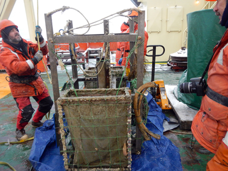
The whale-bone lander on deck after 28 months on the seafloor. Whale ribs bones can be seen attached the at right.  The nylon mesh bin in the aluminum frame also contains whale bones and thousands of colonizing worms. The whale array smells like dead whale.


We then spent 24 hour picking and identifying the diversity of life living on the whale bones, preserving animals for genetic, food-web and biodiversity analyses.  The bone lander contained thousands of dorvilleid polychaetes, amphipods and other animals attracted to whale bones, and promises to provide exciting data for David Honig dissertation concerning food-web structure in Antarctic ecosystems.
By the time the benthic ecology group had finished processing the bone-lander samples late in the evening of April 14th, we had completed our geological sampling, collecting a jumbo piston core 18-m long just north of the Antarctic Sound. The sea ice was extremely heavy, forcing us to head north  towards across the Drake Passage by 200 am on April 15th.  The Antarctic Ice Gods would not let us leave easily – we spend another 16 hours backing and ramming through heavy sea ice before we finally broke into open water just southeast of King George Island.  Now we are “speeding” at 12 knots across the Drake Passage, in the first open ocean swell we have felt for more than one month.   If the fair weather holds, we should be in Punta Arenas by late on April 19th, to unload the ship and head homeward.

Monday, April 9, 2012

Warm winds and frigid mud-busting!

3/25 – 4/7 - Much has happened since our last blog entry, where you left us at our first benthic station (St K), 30 miles off the coast of Robertson Island. After finishing St K, we tried once again to sneak into the Larsen B Embayment, but were thwarted by a line of icebergs acting as sentries over packed multi-year sea ice. We rammed and crunched into the sea ice, creating a deafening noise in the forward parts of the ship, but could not break into Larsen B. We realized we had to accept the overwhelming power of the Antarctic cold and ice, and instead headed northwestward into the area of the former Larsen A ice shelf, to pursue an alternate research plan. Work in the Larsen A will also be extremely exciting, allowing us to explore the effects of ice-shelf loss on marine ecosystems. While disappointed that we could not enter Larsen B, we all recognized that the cold and ice that thwarted our plans create the fascinating, unique ecosystems we are studying here in Antarctica. If we wanted warm, easy sailing, we should have stayed in the tropics!
We worked our way into the Larsen A Embayment along the Seal Nunataks (mountain peaks protruding above an ice sheet) and then skirted along the 17 m (50 ft) high remnant of the Larsen A Ice Self.


The edge of the Larsen A ice shelf, which extends for 30 miles along Nordenskjold Coast in the Weddell Sea.

This ice shelf forms a vertical wall extending to the horizon, and was as an alluring blue in the evening light. We saw a few seals at the base of the shelf, but otherwise the area was devoid of obvious life – a frozen desert abutting a castle of ice. The Larsen A Shelf retreated more than 30 miles between 1977 and 1995, and has retreated more than 100 miles since 1843, opening new ocean waters to whales, seals and penguins during the Antarctic summer. These recently (in geological time) opened waters will be the focus of much of our research activity, where we will explore how seafloor ecosystems have developed once sunlight reached the overlying sea surface, allowing a productive water-column ecosystem to develop.

After skirting the Larsen A Shelf, we moved into Drygalski Inlet, a bay carved by a huge glacier belching icebergs from the Antarctic ice cap. While in Drygalski Inlet, we were treated to a remarkable Antarctic weather phenomenon – Fohn winds. These are winds that drop moisture and warm up as they blow from west to east over the Antarctic Peninsula, and screeching down onto the ship with speeds of >50 knots and temperatures up to 53 F! It felt positively balmy by Antarctic standards, and we worked on deck in light clothing (sweaters and fleece pants). The warm winds lasted for only a few days before we were rapidly plunged back into truly frigid temperatures. The thermometer dropped from 53 F to 4 F within 8 hours. For the past week, temperatures have remained below 0 F, with wind chill as low as -46 F!

The extreme cold has made work on deck both challenging and fun. Mustaches turn to ice within minutes, and we are all shivering within an hour, even in our warmest clothing. Our sampling gear freezes solid on deck, and those apparatus with moving parts (e.g., the megacorer and our yoyo camera system) must be heated and dried in tents or containers before deployment into the sea. Despite the cold, processing the Blake trawl samples is always fun, even if we have popsicle toes.


Paulo, Jackie, Brendan, Laura and Kim processing a trawl at -40 F wind chill. Are those smiles or grimaces? Probably a little of both!

The most coveted job is shoveling the trawl mud onto the sorting screens because the hard labor of shoveling keeps one warm. Mike is the most exuberant wielder of the shovel!


Mike shoveling mud from the Blake trawl – his eyes are smiling (or maybe just frozen open). We must pass all the mud through the sieve table to collect valuable animals for our food-web and biodiversity studies.

The trawl always brings up extraordinary animals, including sea spiders, sea pigs, and an occasional huge octopus. The sea pigs are particularly amazing, and look like little horned aliens.


Jackie and a new friend – it may be love!

We see the sea pigs (weird deep-sea sea cucumbers with many legs and four horns) aggregated in our seafloor photographs, and have debated what a group sea pigs should be called (the most popular term is a “swaggle of sea pigs”). These “pigs” are remarkable creatures that ingest sediment particles and appear to be some of the first colonists at the seafloor after an ice shelf breaks out.


A swaggle of sea pigs (pink horny balloons) and brittle stars at 686 m depth in Drygalski Inlet. The sea pigs are about 10 cm (4 inches) long and are consuming food-rich particles, or “phytodetritus” from the sediment surface.


Craig and Pavica with huge octopus collected in the trawl. This specimen weighed about 15 kilos and was in excellent condition. After photographing the octopus, we released it back into the Weddell Sea.

Now, after 10 continuous days of 12 hour shifts, we are making our way northwards out of the Larsen A Embayment into the Prince Gustav Channel. We have completed four intensive benthic stations, and we now have a day or two of light work, allowing us to take some recreation in the form of the LARISSA Foosball tournament. The prize for the winners will be ………………………………………………………………..….. first dibs on shoveling trawl mud on the frigid back deck!!!

Tuesday, March 27, 2012

Phew!!

3/20/12 – 3/23/12 - In the days since our team’s return from Robertson Island, we’ve been blitzing through a plethora of sampling! With fresh samples of macroalgae from Robertson Island, we quickly went to work isolating, identifying, and preserving our algal specimens for stable-isotope food web studies, taxonomic identification, molecular genetics, and other analyses. As soon as most of the preliminary work with the macroalgae hit the shelves, we arrived at our first benthic sampling station, Station K, by the 21st of March.


Dave Honig of Duke University with a collection of macroalgae from Robertson Island. Image courtesy of Amber Lancaster.

For the time being, heavy sea-ice has prevented the Nathaniel B. Palmer from reaching our primary target area within the Larsen B ice shelf. Thus we have initiated plan B, in which our benthic ecology team will address seafloor community response to ice shelf collapse in the Larsen A embayment, which sustained a major ice-shelf collapse in 1989. We have begun benthic (or seafloor) sampling at our outermost location, Station K. . Here we deployed an instrument called a Blake trawl, which collects lage benthic animals and (and lots of mud) from the seafloor for a defined distance, and then is later hauled on deck for sample processing. We also repeatedly deployed an instrument called a megacorer, which quantitatively samples seafloor sediments and mud-dwelling organisms using twelve tubes (i.e. “cores”) each 10 cm in diameter. Thus, each tube contains many epifauna and infauna (animals that live on the sediment surface, and within it, respectively) with many that are often new to science. Last but not least, our team is also using a system called a “yoyo camera”, which systematically takes pictures of the seafloor and the animals on it by being raised and lowered on a cable, taking a picture every time a weight contacts the seafloor.

Pavica preparing the materials needed for “mud busting” at Station K


A megacorer being deployed off the stern at Station K.

The first Blake trawl was deployed in the wee hours of the 21st of March, and marked the beginning of a slew of sample processing (or “mud busting”, as well call it) on the ships back deck and wet lab. In sub-freezing temperatures and equipped with forceps, the members of the Hawaii team quickly went to work heaving hundreds of pounds of sediment sludge onto a giant sieve table (which is made up of nested sieves with meshes ranging from 2 cm to 2 mm) to separate the megafauna (animals greater than or equal to 2 – 3 cm living on the seafloor) from the rest of the mud. After hours and hours of work, in conditions in which the spray from our wash hoses froze solid on our Mustang suits, encasing us in ice, we finished processing to trawl megafauna. Despite the lack of sunlight and a tropical climate, that night the Aloha spirit could be found persisting near 65º S, 57.8º W.


Mike with a giant sea cucumber, Bathyplotes bongraini, from the Blake trawl.

The following day our team collected another successful Blake trawl, capturing even more animals than last time. Fortunately, we had a few extra hands and worked in the daylight. The trawl sampling was sandwiched between processing of magecores, five of which were collected at Station K. This “mud busting” of megacore samples occurred round the clock for 3 days . Anytime after a megacore deployment is retrieved and placed back on deck, the 12 individual tubes are separated from the megacorer and carried carefully into the processing lab, an aquarium room open the deck. The sediment (mud) in each tube is carefully sliced into precise vertical intervals of 1 to 5 cm and very carefully transferred to sample bottles or plastic bags. Thus, we spend hours very précising cutting “mud pies” from our samples, taking great care not to lose any of this precious deep-sea sediment (no mud fights allows!). These samples will allows us to understand geochemical processes (such feeding by mud eaters) within the sediments, and to quantitatively describe the benthic fauna (i.e. infauna in this case) at various sediment depths. With muddy hands, hair, and clothes, and after multiple days of repetitive processing, our team finished our sampling at Station K happy and satisfied, albeit exhausted.


The Hawaii team picking megafaunal organisms from the table sieve.

Pavica mud-busting!

While everyone was working on >12 hour shifts, with time off used to grab meals and sleep, that’s not to say that we weren’t having fun. In addition to finding some cool marine invertebrates and fish during our sampling, we also ended up running into some of the celebrated Antarctic megafauna. A group of three Emperor penguins off the NBP’s stern, and about 12 penguins off the port side, took great interest in the Nathaniel B. Palmer. Our three aft penguins approaching the ship to within 5 m (15 ft) of the main deck on a bridging ice-floe. Amazing!


Three curious Emperor penguins were spotted not far off the stern of the ship, and slowly approached.


The penguins approached the stern of the Nathaniel B. Palmer to the delight of the scientists and crew.

Monday, March 26, 2012

17-19 March 2012 - Throughout March 17th, we ground through heavy sea ice, making our way south into the Weddell Sea, heading for our work area in the Larsen B embayment. On the day before, we had moved rapidly through the ice-free Prince Gustav Channel to enter the Weddell Sea, one of the coldest bodies of water along the Antarctic continent. This is one of two regions cold enough to form Antarctic bottom water, the densest water in most of the ocean. On entering the Weddell, we quickly encountered sea ice, and our intrepid icebreaker, the Nathaniel B. Palmer (or “NBP”), ground its way through heavy sea ice most of March 17th. The ice was a mixture of new ice formed this late summer season (about 4-6 inches thick), one-year old ice form last fall (2-4 feet thick) and large floes of multi-year ice that can be more than 2 meters thick. Icebergs up to 50 m (165 ft) that had broken off the ice shelves and glaciers in the region loomed over the ship in some areas. The NBP can grind through new and year-old ice, but it is a noisy process, filling the forward parts of the ship, such as the galley were we eat, with a cacophony of roars, bangs, scraping, and thumps as sea ice grates along the metal hull. When the ship is breaking through ice, it is impossible to carry on a conversation in the galley with a ship mate seated next to you. As the ship hits a floe of multi-year ice, there is a loud band, the ship grinds to a halt, and then backs up and rams forward (the “back and ram” icebreaking), or simply circles around thick ice. We stay well clear of icebergs because they can protrude far out under the water, or drop large chunks of ice. Progress through sea ice has been slow, with the ship making 2-4 knots, and often being forced off our desired heading. Work in the frozen Weddell Sea certainly requires patience and flexibility because you often cannot get to a particular location targeted for study.

After a night of raucous ice-breaking, were arrived at the southwest tip of Robertson Island on the morning of 18 March. One of our goals in the LARISSA project is to figure out what food materials are reaching the seafloor in our Larsen B study area. One possibility is that large algae growing in shallow water around the edges of the Weddell sea sink to the seafloor floor to provide food for scavengers such as Antarctic shrimp and sea urchins. Thus, at Robertson Island, Craig and our collaborators from Duke (Dave Honig and Jamieson Clarke) went ashore by Zodiac inflatable boat to sample algae in the island’s shallows. We donned weatherproof Helly exposure suites, and filled a waterproof bag and buckets with sampling gear, drinking water and emergency food (you never know when you might become stranding in Antarctica!). The emergency kit in the Zodiac (a large plastic crate) included tents, more emergency rations, a satellite phones, and other materials. Our shore party also included geologists bent on sampling rocks and servicing an electronic observation station (collecting GPS and weather data) installed on the island two years ago. Our Zodiac boat was operated by two of our Marine Technicians, Buzz and Julian, who steered us through a mile of ice floes past seals and an occasional emperor penguin. We landed on a narrow beach caked with sea-ice and strewn with small icebergs. Most of the coastline of the island was barricaded by sea-ice and bergie bits (small icebergs) making access the shallow water along the beach very difficult


An ice armored beach on Roberston Island- C Smith

We spent four hours on shore, wading in the shallows collecting algae within arms reach, and using a dip net from the Zodiac to sample algae from 3-4 meters depth.


Sampling seaweed in the Robertson Island subtidal - E Hutt

We collected samples of four species of algae for stable-isotope analyses, which will allow us to trace this “food” into seafloor food webs. In the process, our exposure suites leaked, soaking our arms up to our shoulders with frigid (-1.8 C or 29 F), water and we experienced the extreme wind chill of Antarctic islands --- the wind chill was about -25 C (-13F) our entire time on shore, numbing our toes through two pair of heavy woolen socks. Surviving a year in these conditions as did Shackelton’s men on Elephant Island is difficult to imagine! After we collected our seaweed samples, we hiked to the top of Roberston Island (about 200 m, or 650 ft, high) to get the blood flowing back into our toes and fingers. We were treated to a spectacular view looking south into the Larsen B embayment. While extraordinarily beautiful, the view also yielded some disappointing news – our path south into the Larsen B region is blocked by very heavy sea ice and lines of icebergs. Our hopes of getting all the way south to our primary study area appear a bit dimmer!


Craig modeling a Helly suit atop Robertson Island looking south into the ice-clogged Larson B Embayment with the NBP in the background - D Honig)

Wednesday, March 21, 2012

Thursday, Mar 15th Finally in Antarctica! Our first station is in the Antarctic Sound, a strait at the tip of the Antarctic Peninsula. The working day for the science started early this morning; the first rosette with Niskin bottles and the CTD (conductivity, temperature and depth profiler) was in the water before sunrise to collect water samples to investigate the properties of the water column, such as nutrients, and to look at the pelagic microbes.


Laura and Jackie taking water samples from the Niskin bottles

Unfortunately, we were unable to recover the whale-bone lander yet due to some issues with the gear and poor weather. The thick fog that is engulfing the ship offers very little visibility to spot the lander once it rises from the seafloor to the ocean surface, so the principal investigators chose to postpone this operation until later in the cruise. The extreme climate of Antarctica produces fascinating ecosystems, but also often makes our oceanography sampling very challenging.

As we headed further south, the fog dissipated in the afternoon and we spotted the first iceberg of the cruise, and then many more! We are now sailing through the real polar ocean, with ice floes and icebergs everywhere! We watched Adelie penguins running over the ice floes and sliding on their bellies to run away from us; Minke whales inspecting the waters around the icebergs and skillfully navigating in between them; crabeater seals and the fur seals resting on the ice! What an experience on our first day in the Antarctic!


Adelie penguins on an ice floe


Crabeater seal


Jackie enjoying the view of the icebergs

Our second planned station is the Vega Drift, a rapidly accumulating drift of sediment on the eastern side of the Antarctic Peninsula, near Vega Island. The Vega “drift” is formed by current focusing, and is rich with organic matter (yummy to sediment microbes) and and layered sediments (good for reconstructing geological history). We will use a Kasten core to take a sample of sediment up to 6 m long and to give us insights into past processes and environmental conditions in the Antartic Peninsula area over the last 3000 - 5000 y.


Scientists getting ready to take samples of the sediments from the 6-meters long Kasten core (Photo A. Lancaster)


Map of the cruise track starting in Punta Arenas, Chile (at the upper part of the image) and ending on the eastern side of the Antarctic Peninsula (at the lower part of the image) where we are now.
Wednesday, Mar 14th Today, principal investigators from the three science groups (Geology, Cryosphere & Physical Oceanography, and Marine Ecosystems) presented the main objectives and the interdisciplinary science of the LARISSA project. Since we all can get very focused on our own work, we can easily forget the bigger picture, where all the pieces of the puzzle come together to tell the story of the Larsen Ice Shelf glaciers, sediments, and ocean ecosystems; this meeting did a good job to remind us the exciting science behind our Antarctic adventure.


Chief scientist, Maria Vernet of Scripps Institution of Oceanography presenting the objectives of the Marine Ecosystem Group (Photo A. Lancaster)
Tuesday Mar 13th We are in the Drake Passage now, and the weather and the seas are nothing like we expected! It’s sunny outside, temperature 6°C/43°F (wind chill -2.7°C/27°F), with very calm seas and light wind. In fact, some are calling it “Lake Drake!” There is a large high-pressure system covering our entire area, bringing clear skies, 10-knot winds, and only 3-4 foot seas! This kind of weather in the Drake is pretty rare and doesn’t normally last for very long so we are grateful to Neptune to treat us this way! The winds are so weak that there are almost no albatrosses about; They like to glide on the lift provided by strong winds passing over the large Southern Ocean waves in strong winds.

To our surprise, we spotted a lone sailboat coming from the direction of Antarctica. That is the only boat we have encountered so far and could very well be the only one we see during our entire cruise; it would be interesting to know where she is coming from and what stories her crew has to tell.


A lone sailing boat in the Drake Passage

Our Captain Sebastian gives our ETA in the vicinity of the Antarctic continent as tomorrow night and with the first science operation on Thursday morning at 5 am! Everybody on the ship is getting pretty excited!

Tuesday, March 20, 2012

Monday, March 12th. The ship has been rocky a bit since we left Punta Arenas so many of us have been resting today and spending time up on the bridge, which is definitely the place with the best view on the ship. Today’s views included layers of thick clouds and the mountains of the “Land of Fire” (Tierra del Fuego) in the distance. The officers on the bridge are very kind to let us hang out up there and use the binoculars and wildlife guide books. They are also very knowledgeable about the wildlife of this region. So today we saw a few different species of petrels, such as the giant southern petrel and learned that the big, majestic birds that have been following us around and gliding above the waves are black-browed albatrosses.


Mike looking at the wildlife from the ship’s bridge


Sailing between Tierra del Fuego and Staten Island
Sunday, March 11th. We woke up this morning to rainy and windy weather with even some snow even though it’s still technically summer here! But a summer at 53°S, the latitude of Punta Arenas can be quite a different experience than a summer at tropical 21°N of Honolulu, where we come from. A low-pressure storm system brought overcast, strong winds and choppy waters into Punta Arenas and the Strait of Magellan, promising some pitching and rolling even before we reach Cape Horn at the tip of South America.

After finishing several days of fueling, we finally left Punta Arenas in the afternoon to sail eastward through the Strait of Magellan towards the South Atlantic Ocean. Most of tomorrow we will be sailing south along the east coast of Tierra del Fuego, protected by its land mass from the Southern Ocean westerlies. Once we enter the Drake Passage, the place where the Pacific and the Atlantic Oceans meet and the westerlies can build seas for thousands of miles, we may expect much rougher seas.

Today has been a busy day for us. We had a megacore tutorial in the morning, led by the experienced marine technicians, Julie and Jeremy. A megacore is a sampling device that consists of twelve PVC tubes (‘cores’) that are used to collect very high quality samples of marine sediments. It is important that we learn how to remove the tubes from the megacore properly without disturbing the sediment-water interface so we could study the sediment fauna and the microbes living in the mud. As soon as we reach our research stations in the Weddell Sea, we promise to show you the photos of the megacore in action!


Megacore training (Photo by M. Cape)

Our first station will be in the Antarctic Sound, near the tip of the Antarctic Peninsula, where we pan to recover the whale-bone lander that Craig (UH Manoa) and graduate student David Honig from Duke University deployed two years ago. To make sure we are all prepared and know our tasks for sampling the fauna that colonized the whale bones, we had a meeting in the afternoon in which David and Craig familiarized us with the sampling procedure and gave us information on the science behind it. We expect to find new species of bone-eating worms and other animals that require whale bones as a habitat and food source on the seafloor.

The lander consists of a metal frame to which the whale bones are attached; it dropped to the seafloor where it remains for 1-2 yr, attracting colonization by worms, crustaceans and microbes. The whale-bone-associated fauna is very specialized to extract the organic matter out of the bones and resembles the fauna of other chemosynthetic habitats, such as cold seeps and hydrothermal vents. This system is thus suitable to explore a number of broader scientific questions. But we will come back to this in more detail once we recover the bones and the associated fauna! It appears that even after two years at the sea floor, the whale bones could “treat” us with a quit unpleasant smell, but that is not going to distract us from doing science!

Wednesday, March 14, 2012

Delay


Meeting outside Verdemar Gym with our Punta Arenas friend, Juan Pedro Cuevas Cvetkovic, for a game of basketball.

3/8 – 3/10 -- Perhaps not everyone rubbed the brass toe of the Tierra del Fuegan. Our fuel issues have delayed our departure until the afternoon of March 11th. We have used the time for cruise planning meetings, and to have one last basketball game ashore. Pavica constructed her hula hoop, which she will use to maintain peak fitness while at sea! We had a last evening meal ashore; on our return to the ship in the evening, Commerson’s porpoises played around the ship in the moonlight, giving us a preview of the abundant marine mammals we should see at in the Southern Ocean.


Pavica busting out the hula hoop!

Getting ready for life aboard the RVIB Nathaniel B. Palmer (NBP)


Craig and Jackie (the two at left) checking in for their ECW issue. Good spirits all around!

3/5/12 -- Our UH team woke early on the 5th to a hearty breakfast in our hostal and a discussion of ship loading logistics. We then headed down to the USAP warehouse near the ship to be issued our USAP Extreme Cold Weather (ECW) clothing. Very warm clothing, including thermal underwear, insulated pants, down parkas with fur-lined hoods, balaclavas, multi-layered waterproof gloves, heavy woolen socks and steel-toed boots are absolutely essential (especially for thin-blooded Hawaiian residents!) for our work in Antarctica. We will be working during the Antarctic “summer” and “fall”, but in the Weddell Sea, the term “summer” is merely relative. We expect to be in sea ice and temperatures below – 10 C (14 F) for the whole cruise, with wind chill dipping below – 30 C (-22 F). The clothing-issue station was busy with 15 or more scientists trying on their ECW gear. Getting the right-sized gear is very important since we will be working in this garb for >12 h per day “on the ice.”


The USAP logo on an ECW parka.


After our ECW clothing issue, we went to the NBP to check and load our oceanographic gear stored in Punta Arenas from previous cruises. We also inventoried the long list of supplies shipped down from the USA specifically for this cruise. All seemed to be in order, so we then organized and labeled our lab supplies, and began securing (i.e., tying down) our lab equipment for the potentially rough crossing of the Drake Passage. We also set our watches: the Benthic group will work in 12 hour watches of 3 people each. Antarctic research opportunities and ship time are so precious that the ship must conduct science 24 h a day. Science never sleeps!

3/6/12 – We moved out of the Hostal La Avenida and aboard the NBP by 1400 h on the 6th. The rest of the day was occupied with loading and securing of gear and supplies, and buying personal supplies in town for the long cruise. You don’t want to run out of shampoo or toothpaste half-way through the cruise; there are no supermarkets in Antarctica! We finished the day with a pickup basketball game with our Punta Arenas friends. We need to get in shape for the physical challenges of Antarctica!

3/7/12 – The highlight of the day was our ship-safety meeting, where we donned our PFD’s (Personal Flotation Devices), extreme cold immersion suits (popularly called “Gumbi” suits) , and had an abandon-shop drill piling into the lifeboats. The covered life boats appear to be seaworthy, but are very cramped and stuffy. They certainly would bob around like corks so let’s hope we never have to use them!
To day’s lowlight was that our departure will be delayed some days due to fuel issues.


Paulo and Craig heading towards the NBP.


Michael D. (our benthic team member) and Mike McCormick (from Hamilton College) modeling their Gumbi suits during the NBP safety meeting. They are ready to leap into frigid Antarctic waters.

TRAVEL TO PUNTA ARENAS

3/2 – 3/5/12 -- After more than a year of planning, we are beginning our second major research cruise of the LARISSA project to the Weddell Sea. We conducted our first major LARISSA cruise in 2010, but unusually heavy sea ice blocked our southward path into the Weddell Sea, just as it did for Shackleton long ago on the Endurance. Satellite image of the Weddell Sea region suggest that our luck with sea ice may be better this year.

The LARISSA cruise scientists hail from around the world; we have researchers and students from USA, Brazil, Canada, Croatia, South Korea, and the UK. The 6-person contingent from the University of Hawaii (Craig, Laura, Pavica, Michael, Jackie and Paulo), also called the “Benthic Group”, includes three of these nationalities, reflecting the truly international flavor of Antarctic research. The term “benthic” means “of or relating to the seafloor” which is the habitat-type we study.

It has been a very long trip for the “rainbows” from UH to Punta Arenas, Chile, our embarkation port for the cruise. The trip involved 29 to 42 hours of air travel, depending on the route taken, and invariably involves two overnight flights. If you want to work in Antarctica, you must relish long air travel and be able to sleep in an economy seat!


The Magellan statue in the Plaza De Armas of Punta Arenas. Tradition holds that all seafarers misth rub the shiny right big toe of the Tiera del Fuegan for good luck at sea. We all rubbed the toe to insure good luck for our crossing the Drake Passage, the body of water between Cape Horn and the Antarctic Peninsula. The Drake is known as the roughest body of water in the world.

The UH team arrived in Punta Arenas airport on March 4, and were whisked to our hotel, Hostal La Avenida, by agents from AGUNSA, the agency working with the U.S. Antarctic Program to support cruise logistics. The La Avenida is a typical Chilean hostal, with gracious hosts, a hearty breakfast (including “heuvos revueltos”, or scrambled eggs), and a lounge filled with well-worn antique artifacts. The owner is of Croatian descent, and as always enjoyed speaking Croatian with Pavica, our Croatian graduate student, and Craig, our Principle Investigator.


The "Hostal De La Avenida"

After a short nap and a stroll down to the pier to view the RVIB (Research Vessel Ice-Breaker) Nathaniel B. Palmer, our home for the next 40+ days in the Antarctic ice, we all met at the restaurant Cabo de Hornos (Cape Horn) to grab eat and meet-up with fellow research cruise participants. After dinner, we returned to our Hostal, for a luxurious night’s sleep in a real bed!


Our research vessel, the RVIB Nathaniel B. Palmer (NBP) tied along the pier in Punta Arenas. This is a rare windless night in the Strait of Magellan.

Thursday, March 1, 2012

Another long cruise ahead of us!


Satellite image showing sea ice coverage around the Antarctic Peninsula.
In order to plow through the ice to get to our sampling sites we have to rely on the Ice-Breaker Research Vessel NB Palmer.
We will bring news from another great adventure soon!

Aloha!