Tabular iceberg, and natural ice sculpture, as we enter the pack ice east of Ross Island in the Weddell Sea.
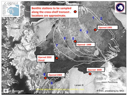
After eight hours of breaking through pack ice, we had made only 20 miles and it became clear that 4-5 days would be required to reach our first destination, Robertson Island, on the edge of Larsen B. We thus decided to head back north around Ross Island and try the western passage, where fast ice (unbroken ice frozen this last winter) was still
in place. We hoped that this would be thinner (less than 2 m thick) and more brittle, allowing the N.B. Palmer to crack through. By the next morning (10 Jan), we plowed into fast ice stretching to the horizon, at first making five knots through a frozen meter white. Then our ship abruptly listed to starboard and ground to a halt; we were stopped by the ice! Our intrepid vessel backed up and then rammed the ice at 7 knots, allowing us to progress for a few more miles before tilting to a halt. The sensation was very much like a sleigh ride over icy snow into a deep snow drift. The ship backed up and tried another route through the fast ice but we still ground to a halt after a couple of miles. Even thought the ice appeared to be only 1 m thick and our vessel Palmer is rated to break 2-m of ice, we were stuck – no more forward progress was possible. Visions of Shackelton on the Endurance danced in our heads. By this time, it was 8 pm on 10 Jan, so we decided to take a rest for the night, and deploy the helicopters for ice reconnoiter and our first rock sampling on the morrow.

The helmsman's view from the ship's bridge as the N.B. Palmer pushes into the fast ice west of Ross Island. It is almost like moving through an Iowa cornfield in cold, snowy winter!
The morning of 11 Jan revealed a glistening white seascape, 2 successful helicopter operations and our fist oceanographic sampling. While the helos flew south and west, the oceanographers“walked on water,” conducting solid-phase oceanography. The ship lowered its gangplank onto the ice, allowing a party of eight to stroll several hundred meters from the ship to collect ice cores and associated ice algae. Ice coring uses tools developed in the 1800’s powered by elbow grease. We collected three cores of10–cm in diameter to measure ice thickness, temperature, and to recover ice algae (diatoms that thrive in the sea ice matrix) for a variety of analyses. The ice crumbled as it fell out of the core tubes; it was “rotten,” i.e., riddled with melt pockets, through most of its 100 cm thickness. this explained why the N.B. Palmer could not break through; the ice crumbled and piled up in front of the vessel, rather than cracking and letting the ship pass through. Bad news for our “icebreaker” because it is not designed to be an “ice dozer”.

One of our two helicopters lands on the N.B. Palmer after the first successful helo operation from the ship during our cruise.

Laura walking on water in front of our ice-bound ship. "I feel like Shackleton!"

Craig uses state-of-the-art technology (a Kovacs Ice Corer) to take an ocean water sample (we call this "solid-phase oceanography"). The party in the background is collecting additional ice cores, measuring the sea-ice temperature, and planning a snowball fight.
After a few hours the helicopters returned with further bad news; rotten fast ice and pack ice continued for the 80 miles into our study area with no open water channels (or “leads”) for the ship to pass through. After much deliberation, the scientific party and ship’s captain decided to abandon the icebreaking for now, and head around to the west side of the Antarctic Peninsula to conduct our helicopter installations of ice and geological stations on glaciers and land. The Antarctic Peninsula is so narrow that our helicopters can fly the 20-40 miles from the west side over the top of the Bruce Plateau to Larsen B, given clear flying conditions to 6000 feet. The evening of 11 Jan found us retracing our course through the fast ice, pushing through our day-old “wake” at 7 knots. All aboard the ship were disappointed by this set back, but hope that we will be able to return soon, once the ice has melted or blown out along the east side of the Antarctic peninsula. It is a bit ironic that our project to study climate warming in the Larsen B area is being held back by an unusually later summer breakout of sea ice!

Retracing our "steps" out of the fast ice in the Gustav Channel. Our course is not difficult to follow!


I think I saw your ice breaker before. It was on the picture on a wall in Punta Arenas Governor House which I visited for prolonging my staying in Chile.Department Chief said he was on board of this icebreaker. He was lucky.
ReplyDelete